Working with a team of forensic geologists, a Reuters investigation used comparative soil techniques to further corroborate our key finding: Bashar al-Assad’s government transferred thousands of bodies from one mass grave in the Damascus suburb of Qutayfah to a hidden location in Syria’s desert. The analysis drew on thousands of drone photographs that were stitched together to create two high-resolution composite images.
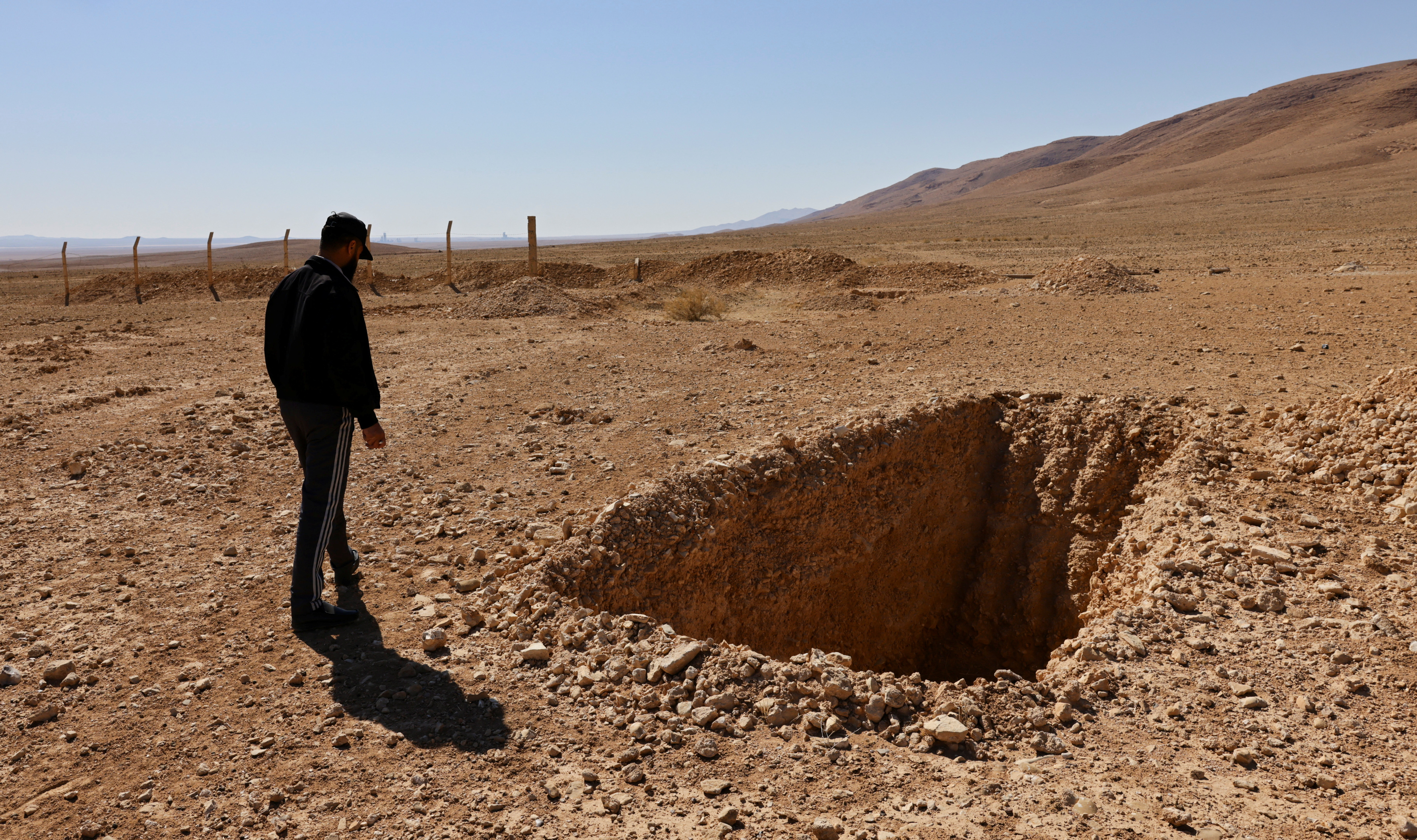
The transfer of bodies and the existence of the new mass grave in the Dhumair desert were revealed for the first time by Reuters last week. How many are buried there remains unknown. Soil samples taken from the two grave sites would provide scientific confirmation of the transfer of bodies from Qutayfah to Dhumair. Exhumation would reveal the number of bodies transferred.
The soil comparison “is one thread of evidence,” said Lorna Dawson, head of the Centre for Forensic Soil Science at The James Hutton Institute in Aberdeen, Scotland, who helped design the Reuters methodology.
“It has to be coupled together with the other information, the other data, the intelligence, the witness evidence. Because as in all investigations, it’s never just one piece of information or one piece of data.”
While analysis of the drone imagery supports the findings of the Reuters investigation, reporters first discovered the site of the mass grave in the Dhumair desert after speaking with more than a dozen people directly involved in its creation. Witnesses included the drivers, soldiers, mechanics and diggers who recalled the years of journeys back and forth between the original mass grave near Qutayfah and the Dhumair site.
The reporting team also reviewed documents signed or stamped by Syrian officers involved in the operation to transfer the bodies. They also analyzed more than 500 satellite images that were key to determining the size of the mass burial site at Dhumair and the pace at which graves were emptied at Qutayfah as new ones were dug at Dhumair.
The transfer of bodies, which was called Operation Move Earth by its creators and was meant to conceal crimes committed during Assad’s rule , took place from February 2019 to 2021.
To corroborate the witness accounts and satellite imagery analysis, a question arose: Was there a way to use science to further establish the link between the two mass graves without tampering with a site that could in the future be treated as a crime scene?
The first of at least 34 trenches in the Dhumair desert site appeared on grainy satellite imagery in early February 2019. That was soon before the start of the transfer there of bodies from the mass grave in Qutayfah, according to eight people involved in the operation.
As Dhumair’s burial trenches were filled, satellite imagery captured at the time appeared to show color changes in the soils around each grave. But atmospheric conditions affect how satellites capture color, and images from even the most sophisticated commercial providers lack the resolution needed for a close examination of the soil.
A FLIGHT PLAN
That’s where the scientists came in.
Benjamin Rocke, a forensic geologist with expertise in using drones to find unmarked burials, drafted a flight plan for Reuters over the two grave sites, directing a skilled drone operator to fly a tight grid pattern at 60 meters altitude, with images snapped automatically every 2 seconds.
One hour and 31 minutes and 2,629 images later, including a short break to change batteries, the Dhumair site was documented. The images of Qutayfah, where the drone operator repeated the flight plan, totaled 2,236.
Syria’s balky internet meant the files took days to upload. When they finally did, colors and features that were blurred in satellite imagery came into sharp focus in the higher-resolution drone images. They revealed bulldozer treadmarks, differing elevations, and patches of soil detailed enough for a direct comparison of the soil colors at Qutayfah and Dhumair.
Under internationally accepted protocol on mass grave protection and investigation, non-invasive techniques are considered the gold standard during initial discovery and documentation of a site, including aerial imagery, satellite imagery, human reporting and the use of documents.
The first time aerial and satellite imagery were used to publicly identify mass graves came in 1995, after the execution of as many as 8,000 Muslim men and boys in Srebrenica by Bosnian Serbs. Madeline Albright, the U.S. ambassador to the United Nations, showed the United Nations Security Council images of burial sites.
Similar to Dhumair, Bosnian Serb forces had relocated thousands of bodies to new sites to conceal them. When investigators started exhuming bodies in Srebrenica after the war, scientists took soil samples from the original and new graves to test for a match. To avoid disturbing the Dhumair gravesite, Reuters did not take soil samples.
Ian Hanson, a forensic archaeologist at Britain’s Bournemouth University who worked on the team at Srebrenica, reviewed the methodology for this report at the request of Reuters. Hanson said chronological imagery analysis of satellite pictures – a method Reuters employed – is an effective way to evaluate the timing of work at the two mass graves. But he said analysis of soil samples from the two sites would be the only way to scientifically confirm the connection between them.
Because the investigators at Srebrenica were able to take soil samples and the sites of the mass graves had different geology, soil and vegetation, the investigators could prove the bodies were transferred from other locations. But even the soil analysis had limits. It took years of painstaking exhumation to reveal the scale of death beneath the surface, and identification of individual remains continues to this day , 30 years after the killings.
The work at Srebrenica was the first systematic use of forensic soil science in a war crimes investigation.
“Any marks that are on the ground that you can see from the air – the geography of that can start to tell a story of what has happened,” said Dawson, whose pioneering work in forensic soil science has led her to become an expert witness in major murder cases. She helped solve one of Scotland’s longest open cases, known as The World’s End Murders after the pub that the two victims left before being killed in 1977.
Rocke’s flight plan called for the drone to fly in straight lines – each about 20 meters apart – back and forth across each site. That ensured the drone took thousands of overlapping photos, allowing photogrammetry software to link them together into composite images 10 times sharper than satellite shots.
Rocke used the drone imagery to compare soil colors from both grave sites using the Munsell system, a standardized classification that organizes colors by the following measures: hue, which shows basic color; chroma, which shows color intensity; and value, which reveals lightness or darkness. The system is used in art, industry and forensic science.
At Qutayfah, the site of the original mass grave, the drone captured detail from empty pits in the earth dug at some point since Assad’s fall – both within the mass grave area and nearby – that revealed red and yellow subsoils of the kind that likely would have been excavated along with human remains, Rocke’s team concluded. At Dhumair, the drone flights showed the disturbed soil was redder and darker than nearby undisturbed areas – the kind of change that would be expected if Qutayfah’s subsoil were added to the gray soil at Dhumair.
Rocke said other factors that would darken soil, including moisture content, mineral composition or chemicals caused by the decomposition of corpses, also pointed to a mix of old and new soils.
Though the scientists’ color analysis indicates the soils may have been mixed, there are still secrets beneath the surface. Only physical sampling can confirm the presence of Qutayfah’s soil at the Dhumair site. Only exhumation and DNA testing can yield the number of dead buried in the Dhumair desert and their identities.


Click here to change your cookie preferences